Antarctic Ice Chart: I Only Have Ice For You
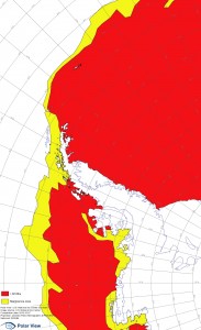
If you are heading to the Antarctic Peninsula this austral summer, or have friends or relatives who are, you might like to take a look at the ice charts freely available at www.polarview.aq. And, depending on where you are going, there’s a good chance you will encounter some ice, as the attached chart shows. This was a compilation of information from December 8, 2012 but it’s revealing.
In summary, there’s a lot of ice around this year.
- Heading south to Antarctica from South Georgia the big decision for expedition leaders and captains is whether to come via the South Orkney Islands and Argentina’s Orcadas Base or to aim for Elephant Island. From Orcades it’s normally an easy run down the eastern side of Joinville Island and in the southern entrance of Antarctic Sound. From Elephant Island the next logical stop is somewhere in the South Shetland Islands.
But not this year – in thee past few weeks the pack ice from the Weddell Sea has drifted out well past the South Orkney Islands (the white dots surrounded by red at the top of the map) and the southern end of Antarctic Sound is blocked. The only option is Elephant Island – but even it seems to be becoming surrounded by more and more sea ice.
The yellow marginal ice zone is generally pretty open water but last week the band of ice (where it kinks out at the northern end of King George Island) required pushing ice aside to get through.
- If you’re on a voyage into the Weddell Sea, good luck. Some ships have reached Brown Bluff but few have made it further east that that – so not really into the Weddell Sea at all. Maybe a big storm will soon change all that.
- For the most visited parts of the Antarctic Peninsula the sea is largely wide open. However there was ice immediately south of the Lemaire Channel and a big iceberg periodically blocking the southern entrance.
- For anyone aiming for the Antarctic Circle, again, good luck. Right now it doesn’t seem accessible and there’s certainly no way further south around the southern end of Adelaide Island or through The Gullet to marguerite Bay.
The proviso to all this is that the most recent accurate ice chart I’ve seen hasn’t been updated for a week. And ice conditions change a lot in Antarctica. A good storm or even some strong prevailing winds move the ice around a lot. And, of course, finding some ice is essential to experiencing the true majesty of Antarctica.
